gpmap draws a map for a specified graphics area. Plots may be drawn in any GEMPAK projection and may be overlaid on images, similar as with sfmap, gpmap can display various types of graphics products including:
ATCF tracksImages are animated if more than one image file is specified in
SATFIL or RADFIL. Images are sampled to correspond to the
geographic area specified by GAREA.
MAP       Map color/dash/width/filter flag
MSCALE    fgc;bgc;mask/units/lat;hide/values/anch/x;y/ln;wd/freq|text_info|t
GAREA     Graphics area
PROJ      Map projection/angles/margins|drop flag
SATFIL    Satellite image filename(s)
RADFIL    Radar image filename(s)
IMCBAR    Color/ornt/anch/x;y/ln;wd/freq
LATLON    Line color/dash/width/freq/inc/label/format
PANEL     Panel loc/color/dash/width/regn
TITLE     Title color/line/title
TEXT      Size/fnt/wdth/brdr/N-rot/just/hw flg
CLEAR     Clear screen flag
DEVICE    Device|name|x size;y size|color type
LUTFIL    Enhancement lookup table filename
STNPLT    Txtc/txt attr|marker attr|stnfil#col
VGFILE    Vgfile | scale file | attribute file | filter
AFOSFL    AFOS Graphics File
AWPSFL    AWIPS Graphics File
LINE      Color/type/width/label/smth/fltr/scflg
WATCH     End time|Wtch clrs|Wtch Tm;Status Ln Tm|Watch Num;
WARN      End time|TS;TN;FF clrs|Tm|Lb|Outline|Poly
HRCN      End time|colors|syms|Tm|Lb|Mt|Qw|F12|F24|F36|F48|F72|F96|F120|Name
ISIG      End time|colors|Sym|Tm|Id|Mv|Fl
LTNG      End time|time ints/colors|markers
ATCF      Time|colors|models|Tm|Id|Mv|Mkr|Name
AIRM      Airmet Plotting Attributes
GAIRM     GAirmet Plotting Attributes
NCON      NCON attributes
CSIG      End time|0_Hr;1_Hr;2_Hr;OL clrs|Seq0|Tm|Mv|Fl|Insty|Seq1|Seq2
SVRL      End time|SVRL clrs|Tm|Lb|Outline|Clr
BND       Bnd name/color/fillsiz/fillpat/filt/minpts!lincol/linpat/linwid!mr
TCMG      End time|colors|center
QSCT      QuickScat Plotting Attributes
WSTM      End time|WN;WT;AD clrs|Tm|Lb|Outline/WN;WT;AD lwidth
WOU       End time|Mrkr and Otln clrs|Tm|Lb|Wt|Clr|Mrkr|Otln|Fill/Fill clrs|
WCN       End time|Mrkr and Otln clrs|Tm|Lb|Wt|Clr|Mrkr|Otln|Fill/Fill clrs|
WCP       End time|Wtch clrs|Tm|Lb|Clr
ENCY      Time|colors|models|Tm|Prs|Mkr|Ccd;wlevs|Fcst_Hour
FFA       End time|FF;FA clrs|Tm|Lb|Ic|Outline/FF;FA lwidth
WSAT      WindSAT Plotting Attributes
ASCT      AScat Plotting Attributes
TRAK1     Jason-1 Ground Track Prediction Plotting Attributes
TRAKE     ENVISAT Ground Track Prediction Plotting Attributes
TRAK2     Jason-2 Ground Track Prediction Plotting Attributes
OSCT      OScat Plotting Attributes
SGWH      Significant Wave Heights Plotting Attributes
ASDI      End time|Mode|DepArr|time increment/clrs or ht range/clrs|time lmt
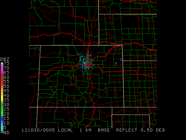
Display the current NIDS Base Reflectivity image overlain with county boundaries and interstates
Begin by finding the latest NIDS file for KFTG (Front Range Airport, near Denver):
 ls $GEMDATA/nexrad/NIDS/FTG/N0Q/ | tail -1
 N0Q_20121030_0005
set RADFIL to this latest file available (full path name), set projection to use to radar file, set the graphics area to the entire set:
 radfil = $GEMDATA/nexrad/NIDS/FTG/N0Q/N0Q_20121030_0005
 proj   = rad
 garea  = dset
 map    = 1
 lutfil = default
 imcbar = 1
After running gpmap to check that the reflectivity scan shows correctly, define the $mapfil variable to add roads and county boundaries, and define map to specify different colors for each map:
 $mapfil = hicnus.nws + hiisus.nws + hiuhus.nws + hipowo.cia
 map     = 23         + 15/1/2     + 14/1/1     + 1/1/1
 GEMPAK-GPMAP>r
You won't find this variable on any user interface, it is a hidden variable. Why? Good question.
$MAPFIL defaults to a medium-resolution political boundary map of the world (countries and states), caled HIPOWO.CIA. Alternate maps, such as lakes, rivers and more detailed political boundaries, can be called as well.
The mapfiles themselves are located in the directory $GEMMAPS. The higher the resolution of the map, the longer it takes to draw (best to use low-res for global maps).
You can specify multiple map files using the + character to separate each file name:
$MAPFIL = file1 + file2 + .... + fileN
The map files are named by concatenating the resolution, map boundaries, and area with the three-letter source file type. For example, the medium-resolution political world map from GSFC is called MEPOWO.GSF (ME = medium, PO = political boundaries, WO = world).
GEMPAK will "remember" the last map file used. If you forgot to reset
$MAPFILafter some customization, the GEMPAK program will use the last definition you entered (on everything).
We will explore mapfiles again in this tutorial, but for now, while still in gpmap, reset the mapfile to the default:
$mapfil = hipowo.cia
Using the latest visible satellite image, display the latest watches, warnings, international SIGMETs, lightning, ATCF tracks, airmets and non-convective and convective sigmets, SLS watches, winter storm messages, and all tropical disturbances.
Be sure that SATFIL is defined correctly!
 MAP      = 1/7
 MSCALE   = 0
 GAREA    = us
 PROJ     = sat
 SATFIL   = $SAT/EAST-CONUS/1km/VIS/VIS_20121029_2132
 RADFIL   =
 IMCBAR   =
 LATLON   =
 PANEL    = 0
 TITLE    = 1
 TEXT     = 1
 CLEAR    = y
 DEVICE   = xw
 LUTFIL   =
 STNPLT   =
 VGFILE   =
 AFOSFL   =
 AWPSFL   =
 LINE     =
 WATCH    = last
 WARN     = last
 HRCN     = all
 ISIG     = last
 LTNG     = last
 ATCF     = last
 AIRM     = last
 GAIRM    =
 NCON     = last
 CSIG     = last
 SVRL     = last
 BND      =
 TCMG     =
 QSCT     =
 WSTM     = last
 WOU      =
 WCN      =
 WCP      =
 ENCY     =
 FFA      =
 WSAT     =
 ASCT     =
 TRAK1    =
 TRAKE    =
 TRAK2    =
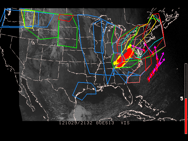
WATCH sets the ending time and the colors for plotting the watches.WARN sets the ending time and the colors for plotting warnings.WSTM sets the ending time and the colors for plotting winter storm warning, watch, and advisory.FFA sets the ending time and the colors for plotting flash flood and areal flood watches.CSIG sets the ending time and the colors for plotting convective sigmets.HRCN sets the ending time and the colors for plotting tropical depressions, storms, and hurricane positions. Optionally, a specific storm name may be entered to display only that specific tropical disturbance.ISIG sets the ending time and the colors for plotting international SIGMETs.LTNG sets the ending time, time increments, colors and markers for plotting lightning data.ATCF sets the time, models and colors for plotting ATCF (Automated Tropical Cyclone Forecast) tracks. As with HRCN, a specific storm name may be entered.AIRM sets the ending time and the colors for plotting airmets.NCON sets the ending time and the colors for plotting non-convective sigmets.SVRL sets the ending time and the colors for plotting severe local storms watches.WOU sets the ending time and the colors for plotting the watch outline update (WOU).WCN sets the ending time and the colors for plotting the watch county notification(WCN).WCP sets the ending time and the colors for plotting the watch corner product.ENCY sets the initial time, colors, model names, and date/time, pressure and marker flags for plotting of the ensemble cyclone tracks.